- Software - Simulation
- Software
- Data acquisition software
- Phoenix LiDAR Systems
Data management software SPATIAL EXPLORERanalysisdata acquisitionfor drones

Add to favorites
Compare this product
fo_shop_gate_exact_title
Characteristics
- Function
- data management, analysis, data acquisition
- Applications
- for drones
- Type
- real-time, 3D
- Deployment mode
- cloud
Description
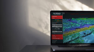
Phoenix LiDAR Systems provides its proprietary software suite for streamlined acquisition, geo-referencing, data fusion & export, with your system purchase.
Support for new cameras (e.g. PointGrey Ladybug5, RGB DSLR cameras, thermal cameras, multispectral & hyperspectral)
Support for new LiDAR sensors 3D map to better choose parts of the scan to extract as LAS
Direct-georeferencing point cloud colorization (no need to wait for photogrammetry results)
Tools for fast LiDAR boresighting and camera calibration allow remounting sensors without downtime
Export georeferenced photos with rich metadata
Easily export/convert raw data from Genicam cameras
Support for CHCX900+ GNSS reference stations, including UHF and 4G connectivity
Robust RINEX conversion for NovAtel/CHC reference stations
Support for Trimble and Leica SmartNet correction networks
Configurable real-time down sampling for complete visualization of longer/larger scans
Easily program rover-integrated UHF modems without leaving SpatialExplorer
Customizable Graphic User Interface
Support for complex/daisy-chained multi-camera setups for synchronous triggering, as well as external trigger inputs
Support timestamped logging of external data via RS232/TCP for 3rdparty sensors (e.g. pyranometers, geiger counters, ...)
Better camera management/image visualization during capture
Additional data layers (e.g. openstreetmap) allow for better orientation while capturing
Raw IMU frequency spectrum helps optimize vibration isolation on gas-powered helicopters and UAVs
Windows 10, 64bit
Minimum 16 GB RAM, more depending on pointcloud size (recommended >= 64GB)
OpenGL hardware support (recommended NVIDIA)
VIDEO
Catalogs
*Prices are pre-tax. They exclude delivery charges and customs duties and do not include additional charges for installation or activation options. Prices are indicative only and may vary by country, with changes to the cost of raw materials and exchange rates.


