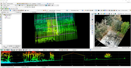
Control software LP360 qualityprocessLIDAR
Add to favorites
Compare this product
Characteristics
- Function
- control, quality, process, LIDAR
- Applications
- for drones
- Deployment mode
- cloud
Description
Process, analyze, and maximize drone survey data, producing valuable information and deliverables
CREATE POINT CLOUDS FROM UAV RAW DATA
Transform and quailty control LiDAR and image data collected from your drone survey equipment.
PROCESS, ANALYZE, & EXTRACT VALUE
Use an extensive toolbox of geospatial tools for deriving products that serve multiple industries and applications.
PUT YOUR DATA TO WORK
Deploy your accurate and fully processed data into actionable results or share with customers.
Drone LiDAR and photo processing workflow made simple
Intuitive workflow
Multi-flight import and processing
GIS interface allowing combination with other geospatial data
Powerful point cloud visualization with multiple and synchronized windows
Process and improve quality of your DJI L1 data
LP360 Drone enhances data from your DJI (P1, L1, P4 RTK, M200 RTK, Zenmuse X4S, and X7S). We start where DJI Terra software ends. Produce final deliverables, including DTM, one-foot contours, classified point cloud, and volumetrics. Step-by-step workflow to:
Manage extensive list of coordinate systems
Separate LAS files by flight lines
Strip align for geometric correction (optional add-on)
Smooth data
• Add GCPs for data QC
Access other tools of LP360 Drone
Improve your data quality
Strip align your data for geometric correction (optional add-on)
Smooth your data to increase precision
Manage your coordinate systems
Extensive list of coordinate systems available
Allow datum transformation including epoch change
Allow reprojection
Local site calibration
Grid to ground
Catalogs
No catalogs are available for this product.
See all of microdrones‘s catalogs*Prices are pre-tax. They exclude delivery charges and customs duties and do not include additional charges for installation or activation options. Prices are indicative only and may vary by country, with changes to the cost of raw materials and exchange rates.


