- Software - Simulation
- Software
- Mapping software
- m-click.aero
Mapping software Aviation Clientfor aeronauticsweb-based
Add to favorites
Compare this product
Characteristics
- Function
- for mapping
- Applications
- for aeronautics
- Deployment mode
- web-based
Description
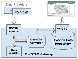
Lightweight, web based Aviation Client application for aeronautical information portrayal and visual data validation. It supports multiple map layers (for weather and terrain data) and provides a tool for spatial and temporal WFS 2.0 query building with support for WFS Temporality Extension (WFS-TE).
Catalogs
No catalogs are available for this product.
See all of m-click.aero‘s catalogs*Prices are pre-tax. They exclude delivery charges and customs duties and do not include additional charges for installation or activation options. Prices are indicative only and may vary by country, with changes to the cost of raw materials and exchange rates.


