- Software - Simulation
- Software
- Server software
- HEXAGON METROLOGY SAS
Server software LuciadFusionanalysisdesignprocess

Add to favorites
Compare this product
Characteristics
- Function
- server, analysis, design, process
- Applications
- for aeronautics
- Deployment mode
- web-based
Description
Provides all-in-one server solution for geospatial data management
LuciadFusion lets you manage your data intelligently, store and process a multitude of data formats and feed data to numerous applications, putting the power of your data at your fingertips. Features including powerful automatic cataloging and quick and easy data publishing allow you to design, portray, process and set up advanced maps in a few simple clicks.
Why you should choose LuciadFusion
Quickly publish large amounts of geospatial data in OGC standard formats with just a few clicks
Eliminate publication delays, even when receiving new images every hour
Share ECDIS maritime data without hassle using OGC Services
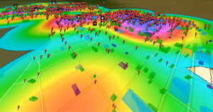
Visualize weather data with temporal information and quickly browse changing weather conditions through time
Display critical elevation data in high-resolution 3D
Share multi-gigabyte shapefiles as WMS without rasterizing them before publishing
Bring line of sight calculations to a web-based application
Connect to more than 200 data sources
Connect directly to hundreds of data formats. LuciadFusion lets you organize your data so that all users have one-click access to a dataset specifically optimized for their needs.
Centralized geospatial data management
Manage and distribute data so users can access it quickly and efficiently. LuciadFusion automatically configures feature data with detailed filtering and styling information.
Get an alternative view of terrain data
Gain detailed insight into the features of terrain. LuciadFusion’s analysis engine is capable of processing data to evaluate elevation and calculate line of sight coverage.
Ready-to-use server solution
VIDEO
Catalogs
LuciadFusion
14 Pages
LuciadRIA
9 Pages
Related Searches
- Software for the aerospace industry
- Real-time software
- Process software
- Maintenance software
- 3D software
- Online software
- 2D software
- Measurement software
- Web-based software
- Automated software
- Server software
- Machining software
- Calculation software
- Data collection software
- Inspection software
- CFD software
- Web browser software
*Prices are pre-tax. They exclude delivery charges and customs duties and do not include additional charges for installation or activation options. Prices are indicative only and may vary by country, with changes to the cost of raw materials and exchange rates.


