- Drones
- Drone equipment
- Mapping LIDAR laser
- HEIGHT TECH Benelux B.V.

- Products
- Catalogs
- News & Trends
- Exhibitions
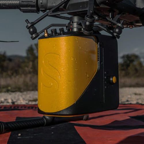
Mapping LIDAR laser YellowScan Mapperfor scannersfor drone3D


Add to favorites
Compare this product
Characteristics
- Function
- for mapping, for scanners
- Applications
- for drone
- Other characteristics
- 3D, GNSS
Description
The next-generation of integrated UAV LiDAR solutions. With Livox technology, YellowScan sets new standards for UAV LiDAR mapping.
YellowScan Mapper LiDAR system
YellowScan is committed to delivering the highest level of performance, reliability, and robustness for our solutions. Fully integrated, ultra-light, and easy to use, these highly automated data collection tools are employed by customers around the world in surveying, forestry, environmental research, archeology, industrial inspection, civil engineering, and mining.
YellowScan’s Mapper is lightweight, fully integrated with embedded batteries, and designed to meet 3D mapping high precision and accuracy needs.
With more than 10 years of experience,
YellowScan’s platforms are field-tested all over the world in multiple environments (tropical forests, bare soils, mountains, rivers, coastlines, open-pit mines, power lines).
Livox-based UAV LiDAR system
With a great point density, this LiDAR sensor allows our LiDAR system to fly easily at 70m AGL with a 120m swath.
We recommend a balanced 10 m/s flight speed to benefit from the Mapper’s point density while being productive. For example, flying at 70m AGL, 10 m/s, you will be able to map 10 ha in 3 minutes.
The YellowScan Mapper is the right LiDAR tool to start with. Your data collection will be fast, accurate and cost-effective.
Livox Horizon Laser Scanner
Applanix APX-15 IMU
High-performance GNSS antenna
External or self-powered
90min. autonomy - external battery
Low-weight, professional solution
Other HEIGHT TECH Benelux B.V. products
Payloads & components
*Prices are pre-tax. They exclude delivery charges and customs duties and do not include additional charges for installation or activation options. Prices are indicative only and may vary by country, with changes to the cost of raw materials and exchange rates.

