
- Products
- Catalogs
- News & Trends
- Exhibitions
Professional UAV FVH850aerial photographymappingtopography
Add to favorites
Compare this product
fo_shop_gate_exact_title
Characteristics
- Domain
- professional
- Applications
- aerial photography, mapping, topography, for the mining industry
- Type
- hexacopter
- Engine type
- electric motor
Description
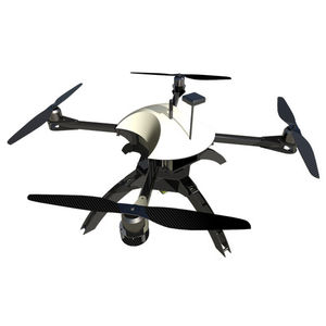
The FalconViz FVH850 drone is the backbone of our operations. Developed entirely at the FalconViz labs, it is designed for deployability, portability, redundancy and ultimate scanning capability. Carrying full frames cameras (50mp), it is capable of achieving extremely high ground sampling density, ensuring high resolution and high precision models can be produced from every flight.
Being a hexacopter, the FVH850 is capable of surviving a motor failure, making it very suitable for operations where safety is paramount. The drone is also completely autonomous, capable of auto-takeoff, auto-mission and auto-landing.
*Prices are pre-tax. They exclude delivery charges and customs duties and do not include additional charges for installation or activation options. Prices are indicative only and may vary by country, with changes to the cost of raw materials and exchange rates.


