- Drones
- Professional drone
- Professional UAV
- Danish Aviation Systems

- Products
- Catalogs
- News & Trends
- Exhibitions
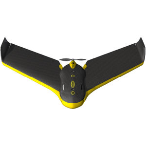
Professional UAV Ebee RTKaerial photographyinspectionmapping

Add to favorites
Compare this product
Characteristics
- Domain
- professional
- Applications
- aerial photography, inspection, mapping
- Type
- fixed-wing
- Other characteristics
- mini
- Autonomy
50 min
Description
Sensefly Ebee RTK
The eBee RTK features a built-in L1/L2 GNSS receiver. This allows it to receive correction data from most leading brands of base station. Its 16 MP camera can shoot imagery at a resolution of down to 1.5 cm/pixel. These images can then be transformed into orthomosaics & 3D models with absolute accuracy of down to 3 cm / 5 cm – without the need for GCPs.
Ground Sensing
The eBee RTK's ground sensor is composed of a high-speed optical sensor and lens assembly that can estimate the distance to the ground with high accuracy. This sensor helps the eBee land softly, in more varied terrain, and with more precision than is possible using only GPS.
SURVEY-GRADE ACCURACY
Absolute orthomosaic / Digital Elevation Model accuracy of down to 3 cm (1.2 in), without the need for Ground Control Points.
FULLY INTEGRATED WORKFLOW
The eBee RTK's software connects to the base station and broadcasts corrections to the rover (eBee RTK) – no additional logger or third-party software required.
BASE STATION COMPATIBLE
The eBee RTK is compatible with most leading brands of base station, working seamlessly alongside your existing instruments.
The eBee RTK can be used in either of three different ways:
- Real Time Kinematic (positioning the base station on a known position)
- Virtual base station (requires internet connection & VRS/Ntrip network subscription)
- Post processing (on-site or in the office later)
VIDEO
*Prices are pre-tax. They exclude delivery charges and customs duties and do not include additional charges for installation or activation options. Prices are indicative only and may vary by country, with changes to the cost of raw materials and exchange rates.


