Management software ALS CWScontrolair traffic managementfor maintenance
Add to favorites
Compare this product
Characteristics
- Function
- management, control, air traffic management, for maintenance
Description
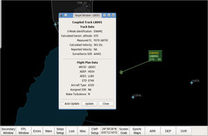
ALS CWS / Ground CWS provides controllers with a clearly structured display of the air traffic/ground situation integrating the surveillance data and the flight data. The position data are received from the tracker and displayed in the main and the secondary radar window, together with other aircraft information on a background of colour maps of Area of Interest (AoI). The flight plans are received from Flight Data Processing System (FDPS) and displayed as fully customizable electronic strips. ALS CWS automatically matches the flight plans to the tracks.
A simple, well-arranged and easyto-integrate module, which displays all necessary air traffic information for ATCOs.
Wide configurability allows easy HMI adjustments according to the client’s needs.
User configuration of HMI features, e.g. colors, display layout, electronic strip classification.
Creating and displaying of so-called private maps directly from the workstation.
Accessible Mapper – a SW tool for map creating and maintenance.
Built on the latest technologies of picture processing (OpenGL) – smooth, no need for special HW, standard PC is sufficient.
Basic tools for archive data evaluation.
Tactical Tool – the utility cooperating with FDP system and providing the list of possible critical flight conflicts based on evaluation of flight plans (points they will fly over).
CWS independent of the FDP system – entering FPL directly.
Intercommunication among several CWS (without the server).
In case of critical system outage, hard-copy of e-strips is available.
Electronic strips display (paper as an alternative).
ASTERIX input format.
*Prices are pre-tax. They exclude delivery charges and customs duties and do not include additional charges for installation or activation options. Prices are indicative only and may vary by country, with changes to the cost of raw materials and exchange rates.


