- Components - Spare Parts
- Avionics
- MFD flight display
- AVMAP S.r.l.U.
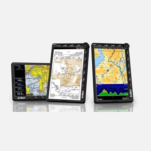
Multi-function display flight display EKP Vprimary flight display800 x 480for aircraft
Add to favorites
Compare this product
fo_shop_gate_exact_title
Characteristics
- Fonction supplémentaire
- multi-function display, primary flight display
- Resolution
- 800 x 480
- Domain
- for aircraft
- Technology
- LCD
- Voltage
- 12-110V
- Other characteristics
- weather
- Size
7 in
- Weight
14.1 oz
- Operating temperature
Max.: 80 °C
(176 °F)Min.: -30 °C
(-22 °F)
Description
Panel mounted and portable at the same time!
Even when cockpit-installed, it is always possible to remove the EKP V from the plane to use it with the internal rechargeable battery for updates, flight planning or training school debriefing.
You can choose between: Cockpit Docking Station or Cockpit Cradle Kit
Light and compact
A brilliant 7” display, with removable battery and built-in GPS receiver, with a weight of just 14.1 Oz, covering an area of only 4.3” x 6.8” and only 0.8” thick!
Horizontal or vertical? Fully customizable!
You can choose the Horizontal or Vertical orientation. You are able to choose what to see and where to display it. You can even set different aircraft profiles and configure the F1 key with your preferences.
Advanced Navigation Technology
A comprehensive software, the result of 30 years of Moving Map and Navigation Technology Know-How. Navigation, Electronic Flight Bag, Primary Flight Display: all you need in a single device, developed with safety in mind.
AvMap Software provides advanced planning functions, great situational awareness, and useful shortcuts in case of emergency.
Much more than a moving map: a true Multifunctional Display!
Through the Cockpit Docking Station, the EKP V can connect to: AvMap A2 ADAHRS, autopilot weather receiver, CAS, video camera and other instrument, to create a complete flight information system.
Moving map excellence: super detailed, with the most reliable official data.
AvMap maps are the result of 30 years of navigation technology and vector maps know-how. Our aeronautical maps include:
Aeronautical Database: Jeppesen data, Avioportolano, Letist
Background: terrain depiction and Land Elevation for TAWS
Catalogs
EVPV Multifunctional display
4 Pages
Related Searches
- Electronic flight instrument system
- Aircraft EFIS
- EFIS EFIS
- Flight display
- Primary flight display flight display
- Aircraft flight display
- Multi-function display flight display
- LCD EFIS
- Liquid crystal flight display
- EFIS flight display
- EFIS with GPS
- Flight display with GPS
- Weather flight display
- 12 V flight display
*Prices are pre-tax. They exclude delivery charges and customs duties and do not include additional charges for installation or activation options. Prices are indicative only and may vary by country, with changes to the cost of raw materials and exchange rates.


