- Drones
- Professional drone
- Professional UAV
- AUTEL EXPLORE THE WORLD
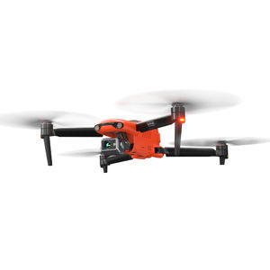
Professional UAV EVO series inspectionfor firefightingrotary wing

Add to favorites
Compare this product
fo_shop_gate_exact_title
Characteristics
- Domain
- professional
- Applications
- inspection, for firefighting
- Type
- rotary wing
- Engine type
- electric motor
- Maximum load
1,270 g
(44.8 oz)- Maximum altitude
800 m
(2624'08" )
Description
Centimeter-Level Positioning
The EVO II RTK Series V3 introduces a brand-new RTK module, which provides real-time centimeter-level positioning data, and supports Post-Processing Kinematic (PPK). The aircraft can record the original satellite observation data, camera exposure parameters and more. The positioning system supports an RTK base station and NTRIP RTK network, which help to achieve accurate and stable data acquisition in complex operation environments.
No GCP Required
EVO II RTK Series V3 can connect to an NTRIP network and does not need GCPs to provide centimeter-grade accuracy.
3rd Party Base Station Support
EVO II RTK Series V3 supports all NTRIP-compatible base stations.
Autel Explorer For Mapping
Multi-NTRIP Profile Saving
For repeatable data acquisition missions, you can record the drone's previous shooting positions. All the gimbals, camera, and aircraft movements will be replicated, thus producing a full record of the entire mission.
Photo Replication
For repeatable missions, you can record the drone's previous shooting parameters. The gimbal, camera, and movement settings will be replicated, allowing missions to be easily duplicated.
Multi-Battery Missions
The Explorer App allows the user to create and save multiple NTRIP profiles for different locations, so they don't have to manually input new a flight plan for every new location.
Advanced Feature Sets
Create Rectangular or Polygon Missions
Supports Double grid mapping for additional angle customizable
Have complete manual control over camera settings
Non stop turning on corners saves time and battery life
Customizable course headings to meet orientation requirements
VIDEO
Catalogs
EVO II RTK Series V3
10 Pages
*Prices are pre-tax. They exclude delivery charges and customs duties and do not include additional charges for installation or activation options. Prices are indicative only and may vary by country, with changes to the cost of raw materials and exchange rates.


