
- Products
- Catalogs
- News & Trends
- Exhibitions
Management software monitoringprocessfor aeronautics
Add to favorites
Compare this product
Characteristics
- Function
- management, monitoring, process
- Applications
- for aeronautics
Description
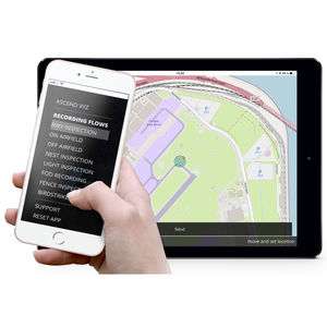
Imagine a 13 km survey that includes satellite monitoring, automated reports and a specialist assessment that can be used as a part of your wildlife risk management program. With the Ascend 13 km satellite monitoring service, we will provide your airport with:
· A complete 13 km survey
· Landscape change identification
· Off-airfield wildlife registration
Process description
Satellite monitoring: Your Airport is mapped by satellites on a monthly basis
Identifying changes: Online satellite maps are made available to you
The 13 km satellite report: Available to you as a pdf report
Register sites: Combine the identified changes with local knowledge
Plan your actions: Continue monitoring, on-site inspections or talk to land owners
Site monitoring cycle: Monthly satellite monitoring of specific sites
On-site visits: Wildlife is observed and quantified
Mitigation and risk: Assess the problem. Can it be mitigated? If yes how
Track water movements
Water attracts wildlife, therefore it is important to monitor. Based on multispectral data from the sentinel satellite constellation we can map water bodies. Using this solution we can identify changes that could impact wildlife behaviour. The “water map” is available in the Ascend web-portal, but take a second and try it out below
1. Satellite monitoring
Your airport will frequently be mapped by the Sentinel-2 Earth observation satellite constellation, developed to perform terrestrial observations such as landscape changes. The satellite data will be made available to you
2. Identifying changes
The digital satellite maps let you, or our wildlife specialist, identify changes to the safeguarding zone, that impact wildlife behaviour.
*Prices are pre-tax. They exclude delivery charges and customs duties and do not include additional charges for installation or activation options. Prices are indicative only and may vary by country, with changes to the cost of raw materials and exchange rates.


