- Software - Simulation
- Software
- Mapping software
- Airelectronics
Control software U-Seeanalysisfor mappingfor drones
Add to favorites
Compare this product
fo_shop_gate_exact_title
Characteristics
- Function
- control, analysis, for mapping
- Applications
- for drones
- Type
- real-time
Description
Our software for controlling UAV is developed in a platform independent way. Thus, it is up to you to decide if you want to use a Windows, MacOS X or Linux laptop to use with your system. It simply will work. We recommend, though, using the MacBook Pro 13” with BootCamp Windows, but again, it is up to you to decide which hardware & software you want to use.
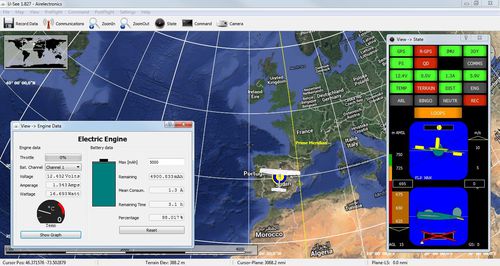
The ground software has been developed using all the lesson learnt with the contact of UAV operators. While other systems have a complete set of parameters stored in the computer and another completely different set on board, our system shows what is receiving from the auto-pilot. This reduces catastrophic omissions (e.g. Forget to upload a waypoint) and considerably simplifies system operations.
Again, following this philosophy, what is drawn on the map is what the UAV intends to do, always. You will be able to see the planned course of action at every moment and modify its flight in real-time
The map engine connects to the internet and fetches georeferenced maps and present them for you. You do not have to manually load maps and worry about their aligment. And if, during your mission, you spot something of interest, you will be able to guide there the UAV with a single click on the interface.
And, having in mind making your life easier as an operator, you can convert the recorded flight file into MatLab® or Excel® files for further analysis. Additionally, if you are interested in modifying the control parameters, you can get the Gains Tuning option.
HighLights
Maps from the Internet. There is no need to download the maps before the use.
Simple program interface. Easy configuration and use.
Catalogs
*Prices are pre-tax. They exclude delivery charges and customs duties and do not include additional charges for installation or activation options. Prices are indicative only and may vary by country, with changes to the cost of raw materials and exchange rates.


