- Drones
- Professional drone
- Professional UAV
- AheadX Tech (Beijing) Co. Ltd.

- Products
- Catalogs
- News & Trends
- Exhibitions
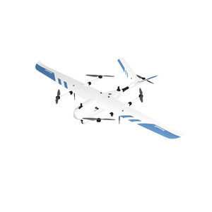
Professional UAV QP532 mappinginspectiontransport
Add to favorites
Compare this product
Characteristics
- Domain
- professional
- Applications
- mapping, inspection, transport
- Type
- fixed-wing
- Engine type
- electric motor
Description
Powerful Flight Performance
From the aspects of structure, material and power, QP532 delivers long endurance, safe and convenient experience.
Environmental Adaptability
QP532 can easily handle severe weather ranging from -20 ℃ ~ 50 ℃, it will accompany you day and night to everywhere in the world.
Quick Disassembly, Convenient Transportation
Quick disassembly structure design, portable transport case, quick operation.
Smart Battery Management
Support self-heating, real-time monitoring of health status to eliminate potential safety hazards.
Safer Redundancy System
Redundant hardware design provides safer flight protection in extreme situations.
Omni Directional Safety Monitoring
Comprehensive monitoring of motor, servo, and structural status to prevent any problems that may occur.
Deep Integration of Multiple Payloads
SHARE camera, RIEGL lidar and other payloads are deeply integrated and ready to use.
Emission Frequency: 100KHz
Accuracy/Repeatability: 15mm/10mm
Max./Min. Measuring Range: 330m/3m
3D GCS, Easy to Use
3D map display, route planning, real-time elevation warning, one-click deployment of fully autonomous operations.
Galaxy Cloud Management System
Support team management, cloud monitoring, log replay, drone ownership/authorization management and other functions.
Cloud Monitoring. View drones' dynamic state anytime and anywhere, plan and control the overall situation.
Emergency Protection
Fearless of danger with a variety of emergency protection strategies.
Emergency Landing
In case of emergency, it can be landed to the landing point collected before operation.
*Prices are pre-tax. They exclude delivery charges and customs duties and do not include additional charges for installation or activation options. Prices are indicative only and may vary by country, with changes to the cost of raw materials and exchange rates.

