Management software eMotionqualityflight planningfor aeronautics
Add to favorites
Compare this product
Characteristics
- Function
- management, quality, flight planning
- Applications
- for aeronautics, for drones
Description
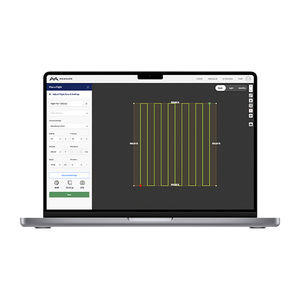
Flight planning software for eBee drones. This easy-to-use desktop ground station allows you to intuitively plan your missions, interact with your drones during the flight and prepare the data for post-processing.
Easy to use
Beginner-friendly yet packed with advanced features to tackle the toughest jobs, eMotion simplifies every step of your mapping project, helping to get your eBee in the air quickly, so you can focus on what’s important – analyzing geospatial data.
Flight plan autogenerated
Draw the area you want to map and eMotion creates the flight plan.
Preset or custom settings
Adjust the mission parameters or select the optimized preset settings for the project type, the camera used, and the terrain.
Optimized flight modes
Horizontal, corridor, point of interest (POI), multiple and custom.
Suits various industries
Agriculture, utilities, environmental, surveying, mining, humanitarian, governmental, disaster management, coastal and more.
Flight simulator
Flying experience recreation with included RTK/PPK. Possibility to modify parameters to see their effect on the drones.
Mission creation in 5 minutes
Just a few minutes are needed to prepare a simple mission, with the possibility to choose optimized presets or custom settings – GSD, overlap, etc.
Real time info
Drone battery level, home distance, link quality, flight time, altitude, wind, ground and air speed, and more.
Geotagged images
Images are automatically geotagged during flight to provide you with a time-saving advantage in post-processing.
Safety features
eMotion safety features contribute to the regulation advantages that our drones provide to eBee operators,
Catalogs
No catalogs are available for this product.
See all of AgEagle‘s catalogs*Prices are pre-tax. They exclude delivery charges and customs duties and do not include additional charges for installation or activation options. Prices are indicative only and may vary by country, with changes to the cost of raw materials and exchange rates.


