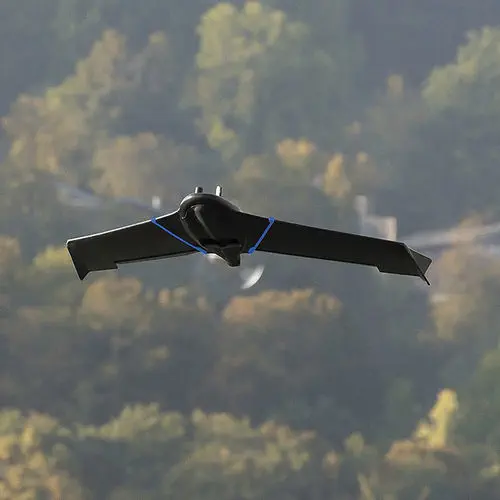
Professional drone eBee Geo for the construction industryfixed-wingelectric motor

Add to favorites
Compare this product
Characteristics
- Domain
- professional
- Applications
- for the construction industry
- Type
- fixed-wing
- Engine type
- electric motor
- Maximum load
10 kg
(22 lb)- Autonomy
45 min
Description
Capture more while reducing field time and costs
Affordable fixed-wing drone designed to meet the needs of surveyors, civil engineers and GIS professionals, thanks to its photogrammetry RGB built-in camera.
eBee Geo 45-minute flight time allows you to cover up to 160 ha / 395 ac at 2.5 cm / 1 in with RTK available.
RGB optimized camera
eBee Geo comes with the senseFly S.O.D.A., a photogrammetry camera built for drone applications. It captures sharp aerial images to produce georeferenced orthomosaics, digital surface models (DSM) and point clouds.
2.5 cm / 1 in absolute accuracy
Available RTK allows you to achieve the high precision accuracy your project requires, down to 2.5 cm / 1 in without GCPs.
eBee Geo’s light weight allows users to operate safely within more regulatory frameworks worldwide and perform advanced operations, such as flying over people (OOP).
During the 45 minutes of flight, eBee Geo can cover an area up to 160 ha / 395 ac while flying at 120 m / 400 ft.
RTK available
Need greater data precision? eBee Geo is available with Real-Time Kinematic (RTK), positioning GSD down to 2.5 cm / 1 in.
Optimized airframe
Designed to operate in harsh conditions thanks to its shock absorbent underbelly made of reinforced polypropylene woven mesh.
Remote ID and C2
eBee Geo has Remote ID and the European C2 class identification label. The drone is prepared for the upcoming drone regulations in the U.S. and Europe.
Catalogs
No catalogs are available for this product.
See all of AgEagle‘s catalogs


*Prices are pre-tax. They exclude delivery charges and customs duties and do not include additional charges for installation or activation options. Prices are indicative only and may vary by country, with changes to the cost of raw materials and exchange rates.