- Drones
- Professional drone
- Professional UAV
- Aeromao Inc.
- Products
- Catalogs
- News & Trends
- Exhibitions
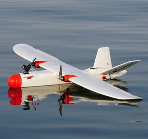
Professional UAV Aeromapper Talonmappingaerial photographyinspection

Add to favorites
Compare this product
fo_shop_gate_exact_title
Characteristics
- Domain
- professional
- Applications
- aerial photography, mapping, surveillance, inspection, agricultural, search and rescue, for the mining industry, topography, oil & gas rigs, for training
- Type
- fixed-wing
- Engine type
- electric motor
- Other characteristics
- with night vision
- Maximum load
0.6 kg
(1.3 lb)- Autonomy
120 min
- Maximum altitude
4,900 m
(16076'01" )
Description
For over a decade, the Aeromapper Talon has enjoyed tremendous success and has been celebrated for its outstanding reliability, user-friendly design, and cost-effectiveness. This turnkey sUAS system is the ultimate choice for ultra-precise data collection, scouting, monitoring, mapping, and surveying. Its spacious design allows for the integration of a wide variety of payloads, making it versatile for numerous applications.
The new Sony 61MP RGB mapping camera is now available for even greater performance. Paired with the Emlid Reach M2 multi-band PPK UAV Mapping Kit, this advanced system delivers ultra-accurate, high-resolution results. With the capability to map more than 480 hectares per flight at 1.5cm/pixel resolution, it ensures centimeter-level accuracy for your most demanding projects.
In addition, our new range of versatile day/night zoom payloads is designed for long-range surveillance and scouting. These payloads deliver crystal-clear real-time imagery over extended distances, ensuring superior operational efficiency and situational awareness.
Multirotor drones, while effective for short-range or small-scale operations, often fall short when tasked with patrolling vast areas or monitoring distant points of interest due to their limited flight time and slower cruise speeds. If you’re seeking a reliable, cost-effective fixed-wing solution for long-range missions—whether scouting expansive territories or maintaining aerial surveillance over areas beyond 20 kilometers—the Aeromapper Talon is the ideal choice.
With over 2 hours of flight endurance, a cruise speed of 58 km/h, and exceptional wind resistance, the Aeromapper Talon enables users to cover 10 times
VIDEO
Related Searches
*Prices are pre-tax. They exclude delivery charges and customs duties and do not include additional charges for installation or activation options. Prices are indicative only and may vary by country, with changes to the cost of raw materials and exchange rates.


