Maximum load: 20 lb
Maximum altitude: 4,500 m
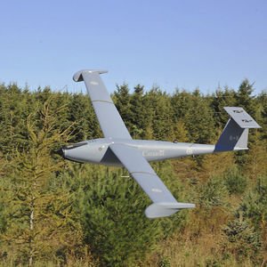
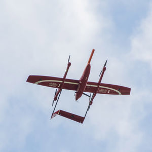
From the ground up, the BAS aircraft Model “TD100” is an outstanding piece of purpose-built engineering. Every aspect of this remotely piloted aircraft system (RPAS) has been designed with the same attention to detail and rigour as a ...
Maximum load: 10 kg
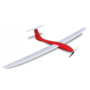
Lightweight mapping drone for large coverage and sharp data eBee X offers 90-minute flights, RTK, PPK, online training, eMotion flight planning software, and more. Perform professional mapping ...
senseFly

Maximum load: 2 kg
... dimensions, the XENA is a vigorous drone allowing numerous possibilities. It can lift up to 2 Kg of effective payload. The XENA is a strong coaxial octorotor drone capable of flying up to 37 min. ...
AltiGator
... high-resolution terrain mapping and precise aerial assessments. Data will be processed into useful visualizations of large land area. Decision makers can respond to threats and manage land to optimize output. Inventory ...

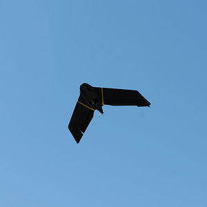
Maximum load: 250 g
Autonomy: 25 min
... stitching software that would allow high-res mapping images taken during a flight to be stitched and processed in a fraction of the time it takes currently. THE MATRIX RTK PACKAGE INCLUDES: MATRIX RTK UAS 3-Axis ...
Xcraft
Maximum load: 15 kg
Autonomy: 24 h
Maximum altitude: 6 km
The SOLARIS and STRATOS are advanced civilian HAPS (High Altitude Pseudo Satellite) UAV systems that offer a low-cost alternative to conventional satellites. With an operational range of 200 km LOS (extendable to +1000 ...
Maximum load: 3 kg
Autonomy: 180 min
Maximum altitude: 20 km
Multipurpose platform with vertical take-off and landing capabilities. – Take-off and landing is performed in so called VTOL mode. Easy, fast and practical take-off and landing. – VTOL mode requires only a small space for take-off and ...
ELEVONX

Maximum load: 5, 9 kg
Autonomy: 2 h
GT20/ GT25 Gyrotrak is Airial Robotics‘ super versatile super Workhorse. A disruptive gyro/helicopter hybrid UAV solution advancing flight time, payload, range and speed over other systems. GT20/ GT25 is built for BVLOS ...

Maximum load: 2 kg
Autonomy: 59 min
Maximum altitude: 60 km
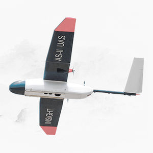
... landing) fixed-wing drone designed to meet the needs of drone mapping and inspections professionals, aerial imaging, precision agriculture, oil and gas, surveillance and monitoring, ...
FIXAR
Maximum load: 7 lb
Autonomy: 90 min
UNMANNED FIXED WING DRONE The Tempest was designed and engineered by Skip Miller Consulting specifically for the University of Colorado. The plane fit the University’s requirements for the National Science Foundation ...

Maximum load: 5 kg
Autonomy: 120 min - 150 min
Maximum altitude: 0'00" ft - 5000'00"
... survey and mapping solution. Development The GosHawk™ platform has been developed by V-TOL Aerospace to provide a low-cost, easy to use and reliable extended line-of-sight (LOS) ready mini-RPAS capable of conducting ...
V-TOL Aerospace

Maximum load: 20 kg
Autonomy: 648 min
Maximum altitude: 5,000 m
Mapping, Photography and aerial surveillance • Type: powered fixed wing (wingspan 4,000mm (157.48”) • Other characteristics: Take off runway 20-50M • Power plant: single motor gas 100cc • Flight controller: Challenger ...
Challenger Aerospace Systems

Maximum load: 3 kg
Autonomy: 55 min
Maximum altitude: 20 km
... aka “drone-in-a-box”) is a non-tethered and easy-to-transport Autonomous drone system. Powered by a standard power outlet, the system needs 35 minutes to charge and gives the drone 55 minutes of free ...
HEIGHT TECH Benelux B.V.

Maximum load: 5 kg
Autonomy: 47 min
Maximum altitude: 16 km
Designed to perform- crafted by hand in The Netherlands. Motors Acecore brushless motors Autopilot Cube Power Tattu 4500mAh up to Tattu 17000mAh Wind resistance 30 knots/ 15.4 m/s continuous DOWNLOAD SPECSHEET Datalink ...
AceCore Technologies
... commanders. Mapping 360 Skyview VR Drone technology has created a unique ability to offer a new level of imagery to the Google Earth and Bing mapping projects. By utilizing autonomous ...

Maximum load: 10 kg
Autonomy: 90 min
... compliant mapping drone Designed to provide 1.5 cm / 0.6 in of absolute accuracy with available RTK / PPK and to cover an area up to 500 ha / 1,235 ac. Offering up to 90 minutes of flight time, the ...
AgEagle

Maximum load: 30.4 kg
Autonomy: 55 min
Maximum altitude: 30 km
A heavy-duty industrial UAV designed to enhance deliveries and flight times. Lift More & Fly Further The Draganfly Heavy Lift Drone is a versatile, multi-rotor unmanned aerial vehicle (UAV), ...
Draganfly Drones
Maximum load: 2.5 kg
... All Easy Aerial UAVs are field-proven, NDAA Sec. 848 compliant, and built with qualified traceable components. Only American-made parts are used in critical systems, such as communications modules and flight controllers. ...
Easy Aerial

Maximum load: 12 kg
Autonomy: 60 min
Maximum altitude: 5,000 m
Quadcopter Patrol Drone Front-facing FPV Lens •500W Pixel Wide-angle HD Network Port Camera •Accurately Identify Obstacles Ahead The fuselage is highly powerful and lightweight •Carbon fiber board + engineering ...
MMC

Maximum load: 300 g
Autonomy: 50 min
Maximum altitude: 3,000 m
... designed for mapping. It is capable of carrying a 300 Gram payload. Most mapping cameras are under 300 Grams. The UAV is electrically powered with a very low dB level. The aircraft is ...

Autonomy: 2 h
Maximum altitude: 120 m
... payload bay supports the best mapping cameras available and custom integration. Vertical takeoff and landing: Fly from anywhere with autonomous VTOL capability. Vertical Takeoff and Landing VTOL Drone The ...
Swift Radioplanes

Maximum load: 15 kg
Autonomy: 75 min
Maximum altitude: 5 km
The drone model KWT-X6L-15 can work with 15Kg load, with flight duration up to 30 minutes and flight distance up to 20Km. If it works no payload, its flight duration can be 75 minutes, and flight distance up to 40Km. The ...
ALLTECH

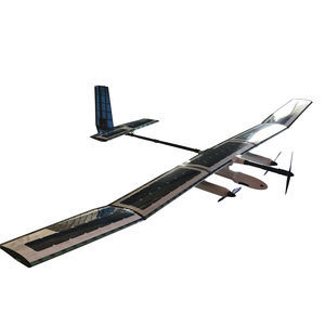
Maximum load: 5 kg
Autonomy: 12 h
... example mapping missions are ideal for the default cruise of 50 km/h. Furthermore, each wing contains control surfaces that maximise flight safety and trajectory accuracy, thereby adding further redundancy and control. Solar ...

Maximum load: 2.5 kg
Autonomy: 120 min - 240 min
... multirotor that provides up to 4 hours of operational flight time with only 25 kg MTOW. Its unique features make this hybrid drone a very versatile platform that will help you accomplish your missions faster than ever ...

Maximum load: 200 kg
Autonomy: 85 min
SMALLEST and LIGHTEST professional hand-launched mapping drone Optimize surveying and mapping Boost intelligent digital industry Solutions for intelligent digital industry Accurate ...
Shenzhen Joyton Innovation Technology Co., Ltd.
the best suppliers
Please specify:
Help us improve:
remaining