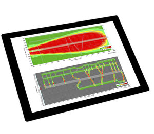
ELISE by NAVBLUE Controlling interference ELISE by NAVBLUE uses full 3D interference simulation software, developed by Airbus using the calculation power of its supercomputer. It can ...
... advantages. CrashGuard Studio is the perfect addition to any CAD/CAM software, as well as to the WFL collision prevention software CrashGuard. With the help of material removal simulation, 3D ...
WFL MILLTURN TECHNOLOGIES GMBH & CO KG
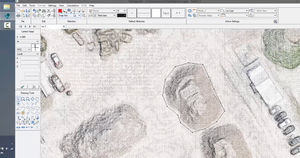
... control input are some of the season-bound tasks that Pythagoras can handle. Import GPS data and UAV images allows to create 3D models and maps in order to perfectly plan the work process in an all-in-one ...
ArView PC Software can be used to configure ArNav devices and view navigation data. ArView PC Software supports following features: Magnetic Calibration Data View Device Settings 3d ...

... to the PADS4 Designer module, whatever the resolution or orientation of your display, whether passive or interactive, in 2D or 3D, very easily adapt your plan to your sector of activity ...
Create a 3D digital twin to visualise and optimise today's operations. Identify improvements by altering daily operations and explore how to | improve efficiency, safety, and profits. Auto-Sim can alsobe ...
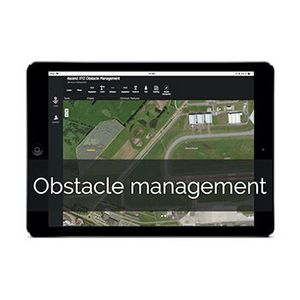
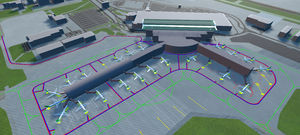
... by your limitation surfaces identifying and classifying obstacles. This is done by comparing a surface model with the digital 3D model of your limitation surfaces. LiDAR is used to ensure the detection ...

3D Modeling Software SpaceClaim now included in Discovery Modeling license Ansys SpaceClaim is the perfect modeling solution for engineers who want access to 3D ...
ANSYS FRANCE SAS

... world-leading platform with a full 3D real-time environment and enabled physics engine to model a system as close to the physical world as possible. A virtual model of the layout is constructed and ...
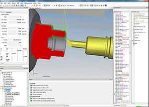
... operation is, roughing, semi-finishing or finishing, the benefits are substantial: reduction of milling time execution on 3D profiles (average saving is 15-20 %, up to 30-40%) improvement of the machined ...
FIDIA SPA

iniBuilds is a cutting edge simulation software company with extensive expertise in geospatial imagery, 3D modelling and texturing, and complex system simulation. Our world class products ...
iniBuilds Ltd

... users the controls they need while reducing unneeded clutter. This simple, easy to use software is supplied with all Draganfly UAV platforms and includes a Software In The Loop simulator for training ...
... multispectral & hyperspectral) Support for new LiDAR sensors 3D map to better choose parts of the scan to extract as LAS Direct-georeferencing point cloud colorization (no need to wait for photogrammetry ...
... relabelled as roof details and facade points. Vegetation is sliced into three vegetation heights (low, medium, high). Based on a 3D search radius and the point count within this radius, non-vegetation ...
... solutions for easy, consistent identity enforcement and user management. Connect, simplify, and automate workflows Connect our 3D print solutions to other enterprise systems through APIs so users ...

... saved for every analyzed point, and full images may be saved for full-field analysis in Vic-2D or Vic-3D.Measurement System Feature OverviewThe Vic-Gauge 3D ...
isi-sys

... Ensuring reliable production quality is important to all additive manufacturing (AM) projects and especially so to industrial metal 3D printing. The EOS Smart Monitoring* Plan is the ideal solution. EOS ...

... 5.0 version. 3D Viewer One of the most striking innovations of RITA® 5.0 is the 3D Viewer, which provides a clear vision of the intended tank based on a three-dimensional ...
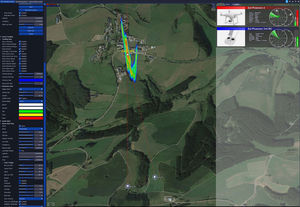
... provides a simultaneous 2D and 3D view, topographic terrain structures with complex 3D models of the areas to be secured (airports, cities, industrial ...
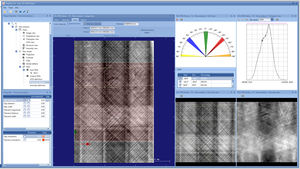
... sophisticated and automated interpretation of your eddy current data necessary? EddyEVA is design to assist evaluating captured 2D and 3D scan data. Saving, loading and applying assessment ...
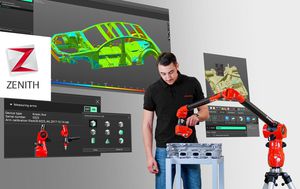
... for acquisition and 3D measurement of industrial parts. Simple to learn, and free*, but able to manage dense point clouds and color mapping, this is Zenith. Fast point cloud acquisition Manage large ...

... a stand alone software package that turns any SEM with digital imaging into a true surface metrology device. Using stereoscopic images the software automatically retrieves 3D ...

... thousands of aerial photographs into precise 2D models or 3D point clouds. Based on our own and our customers’ experience the Pix4Dmapper Pro is one of the best tools available on the ...
... generators. This ensures an unmatched inspection quality and efficiency for non-destructive testing applications. A sophisticated 3D inspection module allows reconstruction with Computed Tomography (CT). ...

We conduct an R&D project on Mixed Reality utilization for operation, maintenance and training of carriage systems manufactured within our group. Indeed, Rafaut and Alkan, pillars of RAFAUT Group, are the french worldwide ...
the best suppliers
Please specify:
Help us improve:
remaining