... -A/C only, Mode-S, ADS-B) together with information about the target in configurable text form. In addition to the 2D display, a 3D view is featured to show the current traffic situation ...

The Reverse Engineering Module is used to analyze in detail an existing aircraft to figure out among other its aerodynamic efficiency (Maximum lift coefficient, maximum lift increment, friction coefficient, zero lift drag coefficient…) ...
OPTIMAL AIRCRAFT DESIGN
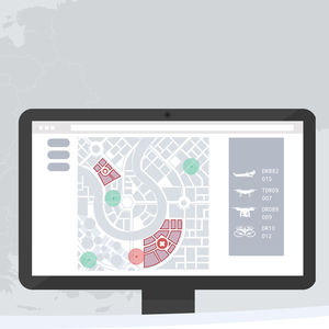
... Universal Control Software (UCS) is a central point where you can manage all your unmanned vehicles. It does not matter whether you have one drone or a fleet Tor Universal Control Software will suite ...
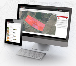
... cloud-based mapping and analysis softwareScout easily and get insights from your drone data with PrecisionMapper. Create 2D and 3D maps and analyze your orthomosaics to get valuable insights ...
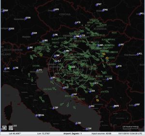
Airspace Security Management Combine UTM and drone detection (C-UAS) capabilities to detect, identify and differentiate all air traffic within airports and critical infrastructures. Drone traffic detection Ground-based radar systems ...
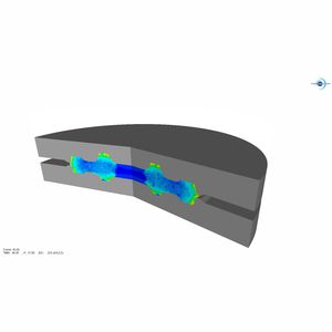
Aerospace forged components producers face the challenges of designing, testing and delivering their products on-time and on-budget together with producing parts complying with the in-use properties requirements.Since the beginning, TRANSVALOR ...

... -cycle. Data4Flight® helps you to generate ARINC coding by importing flight procedures and allowing you to view them, in 2D or 3D, using Google Earth®. DATA4Flight® also offers a variety ...
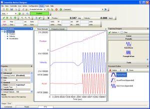
Design Features Importing an existing trajectory consisting of position, velocity and/or acceleration state vectors from an external file Plotting trajectories and using analysis tools such as cursors and frequency domain estimation Creating ...
AEROTECH
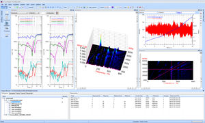
... maps and advanced computed order tracking. The software uses intelligent wizards that, step by step, guide through the process of performing a rotating machinery data acquisition and analysis. Waterfall and 2D ...

... Helix Point of Sale: a software for the management of a point of sale with operators. Helix Report e Statistiche: a reporting software for sales and access analysis purposes. Helix E-commerce: a software ...

... geometry based on 2D drawing data and parameters through input of diameters, pitches, wall inclines, radii, bar or channel widths and depth profiles with 2D modulo representation ...

... the boarding time of each and every passenger, saving valuable seconds that add up. Fully compatible with modern, mobile 2D barcode readers and Damarel’s L-DCS and Embark products, EMBARKmobile is ...
Damarel Systems International

... to the PADS4 Designer module, whatever the resolution or orientation of your display, whether passive or interactive, in 2D or 3D, very easily adapt your plan to your sector of activity ...

... and simulations. Ansys Lumerical FDTD models nanophotonic devices, processes and materials so you can focus on creation. 2D or 3D Models Advanced Conformal Meshing Flexible Material ...
ANSYS FRANCE SAS

... users the controls they need while reducing unneeded clutter. This simple, easy to use software is supplied with all Draganfly UAV platforms and includes a Software In The Loop simulator for training ...

... are saved for every analyzed point, and full images may be saved for full-field analysis in Vic-2D or Vic-3D.Measurement System Feature OverviewThe Vic-Gauge 3D system ...
isi-sys

... Economical as a stand-alone software solution Combination of code-based and contour-based localization using the LiDAR-LOC 2 application software Flexible solution for applications ...

... 5.0 version. 3D Viewer One of the most striking innovations of RITA® 5.0 is the 3D Viewer, which provides a clear vision of the intended tank based on a three-dimensional preview. The user can switch ...
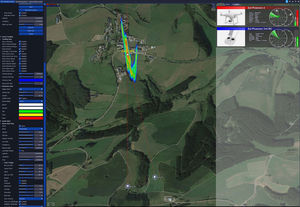
... provides a simultaneous 2D and 3D view, topographic terrain structures with complex 3D models of the areas to be secured (airports, cities, industrial plants). The capabilities ...
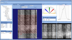
... sophisticated and automated interpretation of your eddy current data necessary? EddyEVA is design to assist evaluating captured 2D and 3D scan data. Saving, loading and applying assessment ...

... thousands of aerial photographs into precise 2D models or 3D point clouds. Based on our own and our customers’ experience the Pix4Dmapper Pro is one of the best tools available on the ...
the best suppliers
Please specify:
Help us improve:
remaining